June 22, 2018: published by Troy Heerwagen at 3:57 pm - Closed
For the first time ever, Seattle’s worst intersection is in South Seattle. Rainier, 23rd, and Hill beat out numerous other contenders to be chosen by readers of the Urbanist as the worst intersection in Seattle for people walking, biking, and busing.
May 22, 2018: published by Troy Heerwagen at 10:29 am - Closed
This year’s competition has expanded from being pedestrian-only to include those intersections that are bad for people busing, biking, and walking. Vote at The Urbanist.
This is the fifth year of our annual tradition of selecting the worst intersection in Seattle and the selection process starts with you.
What do you think is the worst intersection in Seattle?
Last year’s worst intersection
We’re looking for those intersections that are worst for walkers, maybe because of noisy traffic, missing sidewalks, poor signal timing or possibly all of the above, like last year’s worst intersection: Green Lake / 50th / Stone Way.
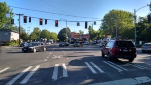
Jonathan Glick and his son live in the Central District and often walk across 23rd Avenue. The street is a major thoroughfare and recently has been rebuilt. One wet evening, they went out to pick up dinner and walked along Union Street on the way back home. But, with dinner in one hand, and his toddler’s hand in the other, Jonathan couldn’t activate the pedestrian signal at 23rd Avenue in time. The awkward reach for the button with a heavy bag of burritos caused the two to miss their chance – leaving them standing in a winter storm until the next light cycle.
Over the course of the past year, Seattle has chipped away at dangers to pedestrian safety and obstacles to comfort. SDOT adopted a Director’s Rule for Pedestrian Mobility In and Around Work Zones, requiring safe access for pedestrians around construction sites and allowing fewer sidewalk closures. And the city council voted to lower default speed limits around the city to a safer 25 miles per hour on arterials and 20 in residential areas.
But there’s still another clear opportunity to improve safety further and substantially improve comfort for people walking: do something about those “push to cross” buttons, better known as “beg buttons”, all over the city.
Begging to cross
Whether you don’t hit the beg button in time or don’t even notice it, you have two options for what to do when you miss your chance for the walk signal like the Glicks did:
If you want to be an obedient Seattleite, push the button and wait your turn. This means you get to see all those cars go in the same direction that you want to with their green light, while you’re stuck standing there and staring at that red hand. Then, you wait for everyone else to go in all other directions, before finally, minutes later, you get your chance to cross. In Jonathan’s case, he stood with his son getting colder and wetter, realizing that the city hadn’t thought enough about pedestrians. For those recent transplants who aren’t familiar with waiting for the signal here’s an example of what it’s like to wait it out:
Feeling frustrated, you might choose another approach…
Eschewing Seattle tradition and risking life and limb, you decide to live boldly and scamper across the street. You then notice those turning drivers that aren’t expecting anyone to be crossing and who suddenly notice you too, in time to avoid making you a hood ornament. Breathless and invigorated, you feel like you’ve avoided the worst until you see that police officer waiting for you on the opposite curb…
Frankly, both options are unacceptable: nobody wants to wait when they “should” have the right of way, but crossing against the signal exacerbates conflict between people driving and walking and is dangerous for everyone. In short, having to push a button to cross makes you inconvenienced at best and vulnerable at worst. And, pedestrians are already the most vulnerable roadway users; people walking who are hit by a car are more likely to die in a collision than bicyclists or drivers.
In a New York Times editorial, Tom Vanderbilt, the author of Traffic: Why We Drive the Way We Do (and What It Says About Us) says, “Pedestrians, who lack airbags and side-impact crash protection, are largely rational creatures.” He argues against beg buttons, saying, “When you actually give people a signal, more will cross with it. As the field of behavioral economics has been discovering, rather than penalizing people for opting out of the system, a more effective approach is to make it easier to opt in.”
“Push-buttons almost always mean that the automobile dominates,” says City planner Jeff Speck in his book Walkable City. He continues, “Far from empowering walkers, the push button turns them into second-class citizens; pedestrians should never have to ask for a light.”
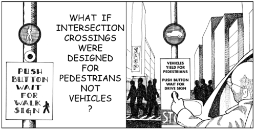
Comic by Dhiru Thadani
In fairness, Seattle doesn’t have beg buttons everywhere, and the Seattle Department of Transportation has criteria that determine where push buttons don’t belong. According to SDOT city traffic engineer Dongho Chang, “This is determined by using counting equipment in the signal cabinet to record pedestrian crossing activation. High pedestrian use is currently defined as when crossing is activated 50% of the cycle for 12 hours. We will be evaluating updates to the guideline.”
And evaluate they should. First, SDOT undercounts the number of people who want to cross by only tracking when the button is pushed and not considering the people who don’t notice the button and the people who defy the button by jaywalking. Second, SDOT undermines Seattle’s Vision Zero plan for zero traffic deaths and serious injuries by 2030 as the stated goal of transportation policy by designing an experience that creates conflicts between drivers and walkers. Besides, these buttons are often unnecessary because in many cases the traffic light is green for plenty long enough to let pedestrians cross if the walk signal were activated, without any changes to signal timing.
To put this solution in perspective, there are some problems with our transportation network that will take millions of dollars to fix, or even billions, such as filling in the missing sidewalks across the city. But no change to our transportation network would be as cost effective at transforming the experience for people walking as removing beg buttons. A change in policy and signal programming would revolutionize what it means to be a pedestrian in Seattle.
People in other cities from Victoria to Venice and from Santa Monica to Sudbury, have made similar arguments against beg buttons, however, no city has changed their engineering approach to improve intersections for everyone.
In a world where Seattle’s political climate is more divergent than ever with national politics, now’s the time to take control of what we can control: our city.
Seattle can do this, and here’s how: ban beg buttons in all urban villages and urban centers and lower SDOT’s engineering threshold to have the beg button be eliminated for the entire day for any crosswalk signal that is activated 25% of the time for any 6-hour period during the day.
Transform the transportation network by positioning Seattle as a leader in safer streets and active transportation. Don’t discriminate against people walking – let all people cross the street at the same time whether walking, driving, or biking.
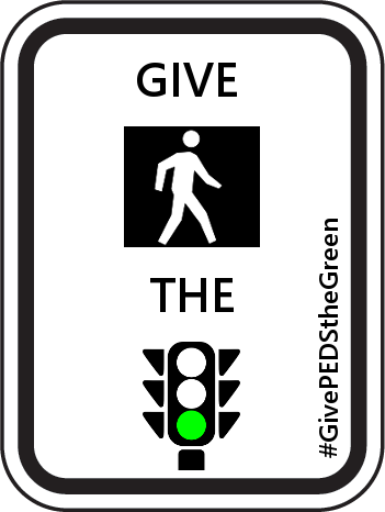
Tell everyone why the beg button should be banned under the hashtag #GivePedsTheGreen.
Push the button. Always. As long as the push button is still used as a measurement of pedestrian activity, be sure to push it to make sure that SDOT counts people on foot when programming traffic signals.
September 14, 2016: published by Troy Heerwagen at 8:08 am - Closed
Seattle is poised to take a major step forward in improving roadway safety by reducing speed limits to 25 mph on arterials and 20 mph on residential streets. The plan, announced by councilmember Tim Burgess yesterday, will be presented to the City Council for a vote later this month.
This change would represent the city’s most significant action to support Vision Zero, Seattle’s plan to end traffic deaths and serious injuries by 2030, and would send a clear message that safety surmounts speed when it comes to our transportation network.
While Seattle is not the first city to consider such a change, the idea may be new to many people. Local safe street advocacy organization Seattle Neighborhood Greenways worked with the city on this legislation and has prepared a list of Frequently Asked Questions, which is re-posted below in full:
Who supports the 20/25 MPH idea?
Many community, public health, school, business, and advocacy groups are asking for safer speed limits. We hope you will too after learning more about how this idea will save lives!
What’s the idea for non arterial streets (neighborhood streets)?
A safe and livable 20 MPH speed limit for every neighborhood street in Seattle. Currently, the “default” speed on non-arterial streets is 25 MPH – faster than you probably drive on neighborhood streets. 20 MPH streets will be safer for us all, particularly people walking and kids playing.
What’s the idea for arterial streets?
Streets that are known to be dangerous should have speed limits examined, and potentially reduced to 25 MPH, as part of a comprehensive safety strategy. Additionally Communities should be able to request the city work with them to reduce arterial speed limits especially in areas such as business districts and through community hubs. Traffic should be smooth and safe and people should be able to get where they need to go reliably and safely. One part of this would be to change the “default arterial speed limit” signs at the entrances of Seattle to 25 MPH to let visitors know that they may encounter 25 MPH arterial streets.
Will changing the speed limit save lives?
Yes. Changing the speed limit will make our streets safer for everyone! Each year in Seattle about 20 people are killed in traffic collisions and another 150 are seriously injured. 42% of of these collisions involved speeding. Driving even a little slower gives us all more time to see each other and makes it easier to stop. Well-established research shows that even a small speed decrease makes a big difference. Vehicle stopping distance improves by 45 feet (23%) when traveling at 25 MPH versus 30 MPH. If a collision does happen, nine out of ten people hit by a driver going 20 MPH will survive, while at 30 MPH survival rates decrease to only five out of ten.
Will 20 MPH for neighborhood streets mean I’ll take longer to drive anywhere?
No. On non-arterial (neighborhood) streets, it is already difficult to drive faster than 20 MPH due to roundabouts and narrow street widths. When people do speed it is especially dangerous for elders and children living and playing in their neighborhoods.
Would a 25 MPH for arterial street make my commute longer?
First of all, this proposal does not change all arterial streets to 25 MPH (see FAQ above). Not likely. Most people drive during rush hour, when it’s already difficult to drive fast. Travel time is primarily determined by factors like traffic signals, congestion, and turning vehicles. Moreover, a top reason for congestion in Seattle is traffic collisions. Reducing speeds will reduce collisions and reduce the frequency of collision-related congestion. People driving outside of peak travel times may see a slight increase in their travel time. If you’re going 30 MPH without any interruptions, a lowered speed limit of 25 MPH will add about 1 minute to your trip (the average car trip in Seattle is about 3.5 miles). We think the occasional extra minute is worth it to save someone’s life.
When would the speed limits change, and which streets would be affected?
A default 20 MPH speed limit for non-arterial neighborhood streets could take effect as soon as the signs could be changed, except where they are currently signed to 15 MPH (as they are in some school zones).
The 25 MPH limit for arterial streets would be implemented on a case by case basis over time with community and SDOT evaluation (this is the model used by every other city in King County). Only then would speed limit signs be changed and a 25 MPH limit enforced.
Are there other cities with 20/25 MPH speed limits?
Yes. 20 MPH neighborhood streets are widely seen as a best practice around the world to keep neighborhoods safe and comfortable places to live in and raise families. Every other city in King County has a default speed limit of 25 MPH or lower. Many other large cities around the world, including New York, Los Angeles, Washington D.C., London, Paris, Berlin, and Tokyo, already have a speed limit set to 25 MPH or lower to improve drivers’ ability to avoid crashes.
Isn’t 20/25 MPH just a way to raise additional revenue for the City?
Not at all. Seattle should reduce its speed limit in order to make the city safer for people walking, biking, and driving. A lower speed limit helps meet the City’s goal of bringing traffic fatalities to zero. Data shows that driving at or below 25 MPH improves drivers’ ability to avoid crashes.
Sometimes streets are just dangerous. Why focus on speed?
Dangerous driver choices, such as speeding, failure to yield, and improper turns, are the primary cause or a contributing factor in 70% of pedestrian fatalities. Legislative efforts, such as lowering the speed limit, combined with engineering street safety improvements, education and enforcement work together to create safer streets for us all.
What is Vision Zero?
Seattle’s goal for traffic fatalities and serious injuries is the same you would want for you and your family: zero (this goal is called Vision Zero). While zero fatalities may seem ambitious, it’s the same standard we expect of our airline system. 20/25 MPH is a great way to improve drivers’ ability to avoid crashes!
This is a guest post by Phyllis Porter and Gordon Padelford. Phyllis Porter is an educator, advocate for criminal justice reform, and leader with safe streets community group Rainier Valley Greenways. Gordon Padelford is the Policy Director for Seattle Neighborhood Greenways.
Rainier Ave S was infamous for being Seattle’s most dangerous street. With a crash every day on average, 7 businesses hit in the past year, and 630 injuries over the last three years, something had to be done. Business, community groups, and residents had had enough.
Last year the community came together to demand Rainier Ave S be made safer. For instance, a group calling themselves the Rainier Road Diet Supporters held a number of crosswalk protests.
The community group Rainier Valley Greenways rallied around a campaign called Safety Over Speeding to bring more attention to the problem. We collected signatures and photo petitions, created a Get Well Soon Rainier Ave Card for people to sign, posted flyers with the number of crashes next to dangerous intersections, and hosted a big crosswalk protest and rally.
The Department of Transportation responded to the community and overwhelming data by doing a safety corridor “pilot” between S Alaska St and S Kenny St, and planned to study an expansion of it for 2016. The pilot included adding a center turn lane to reduce turning collisions, adding bus priority to keep the popular route 7 on time, and improving crosswalks and signals for people walking.
The results are in and they are great! Aggressive speeding (over 40 MPH) is down 95%, injuries involving people walking are down 41%, a fear of bus delays never materialized (the #7 bus has not been slowed down), traffic still flows, and it is now much more safe and comfortable to be in Columbia City and Hillman City. King 5 did a piece on the results and interviewed the owner of Lottie’s Lounge who said “The road diet has really improved the quality of life. The benefits far outweigh the downside.”
The Department of Transportation said they would expand the safety project north to Letitia Ave S and south to Seward Park Ave S if the initial pilot was a success. Rainier Valley Greenways believes it has been, and that all neighborhoods along this dangerous street (not just Columbia City) deserve to be safe. They are hosting a Safe Streets Celebration on August 17th from 5:30-7:30 at the corner of Rainier Ave S and S Edmunds St to thank the city for the initial safety improvements and ask the city to complete the project. They are asking residents to join them on the 17th, and sign a petition thanking the city and asking them to complete the project.
May 13, 2016: published by Troy Heerwagen at 6:30 am - Closed
Note: This post is also published at The Urbanist.
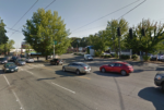
This year’s Worst Intersection in Seattle is the car-choked crossroads where Green Lake Way N intersects with N 50th St and Stone Way N.
Looking south on Green Lake Way N
So many cars are coming from and going to so many different roadways that nobody wins. People stuck in their cars often wait through multiple light cycles as backups can stretch for several blocks in multiple directions. And it’s worse for pedestrians, who also have long wait times and often have to cross more than one street.
The worst experience is walking north from the west side of Stone Way N. People on foot cross a right turn lane and have to wait on a little island, surrounded by a sea of metal and concrete. Then, there’s the wait to cross at least two streets. Yasmeen, who nominated this intersection, says: “There are so many intersections at that point that it can be several minutes before you get a walk light.”
Once through the intersection, it’s a walk in the park – but only in a literal sense as the sidewalk disappears and there are unpaved paths on the edge of Woodland Park. Good luck enjoying yourself if you’re pushing a stroller with small wheels or just wanting to keep your dark shoes clean. This area is busy with joggers, walkers, bicyclists – all sharing a narrow path and wondering what happened to the sidewalk. If you want the luxury of a paved sidewalk, you’ll have to cross yet another intersection to get to the east side of Green Lake Way N.
Seattle Bike Blog calls the intersection “a complete mess,” though people on bikes may be the only ones who don’t completely hate the intersection as North / South bike lanes have been added in recent years.
Of course one main reason why this intersection is so bad is that so many streets intersect here. But, that wasn’t always the case. As shown below, this intersection used to be just one of many four way intersections in the city.
Clipping from 1912 Baist Map of Seattle
However, when the Pacific Highway was built in the early 1930s, traffic engineers sliced through the existing residential grid so that motorists could get to downtown faster. The new road was labeled Green Lake Way N and, like Bridge Way N ten blocks south, required tearing down existing homes to provide access to the new highway, now called SR-99.
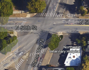
N 50th St / Stone Way N / Green Lake Way N today
So, is this intersection fixable? What if, to borrow a software development term, we rolled the intersection back to a previous version? As suggested by blogger Al Dimond, we could improve the intersection by removing the diagonal route to Aurora and turning it back into a four-way intersection. This extension of Green Lake Way might be a real-world Braess’ Paradox, meaning that removing it could actually improve travel times for everyone. At the very least, as Dimond says, it would create a “more cohesive and walkable neighborhood with more pedestrian-friendly intersections.”
If you’re not sold on that, then commenter Izaac Post recommends a roundabout.
Roundabout concept
Roundabouts are proven to reduce collisions and fatalities. And, while this intersection isn’t one of Seattle’s deadliest intersections, pedestrians would welcome the decreased vehicle speeds that a roundabout would bring. However, the intersection is already pretty complicated, so would a roundabout make it even more confusing? This would be the busiest roundabout in the city and drivers and bicyclists would need to share it. Would bicyclists feel comfortable sharing a roundabout with drivers?
While the city has a Vision Zero plan to eliminate roadway fatalities, the ten terrible intersections we had to choose from and recent rollbacks to the bicycle master plan show how far there is to go toward creating a safe street network that is comfortable for all users. This intersection configuration at the corner of Woodland Park has been with us for over 80 years and it may not change in another 80 years. We should have hope, though, that at least by then there will be paved sidewalks.
Another year, another solid crop of nominees for worst intersection in Seattle; these are 10 of the most dangerous and unpleasant crossings that Seattle has to offer. While all of these need some serious re-engineering from SDOT, only one of them can truly be the worst intersection in Seattle. Read the descriptions, view the photos, and cast your vote.
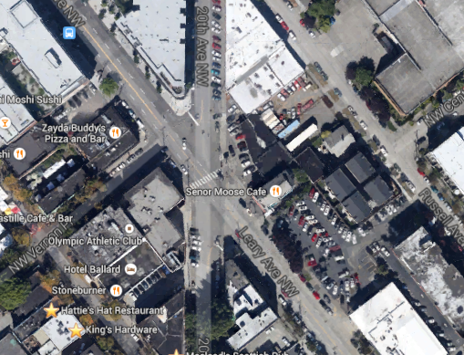
Leary Way NW & 20th Avenue NW – The Urbanist wrote almost 1000 words on why this intersection sucks, “It’s a safety hazard to both drivers and pedestrians. And, if it’s dangerous for both of these groups, it has to be even worse for bicyclists.”
Leary Way NW and 20th Avenue NW
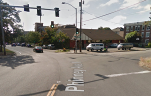
N 50th St & Phinney Ave N – Skylar nominates this one, “Drivers will barrel through the crosswalk at 30+ mph without regards to pedestrians, and in fact probably cannot even see them until they are about 30′ away due to the way the street curves around the zoo”
N 50th St & Phinney Ave N
Rainier Ave S & I-90 – Al Dimond nominates this one and the next one, saying “About half of the top 10 worst intersections in Seattle have got to be along Rainier!” One example is the on ramp onto I-90 “Crosswalk across two exit ramp lanes. One is HOV, so it may be moving while the other is backed up, and it’s also set up so pedestrians can’t tell whether a driver in that lane is going to exit or not until the last second.”
Rainier at I-90 onramp
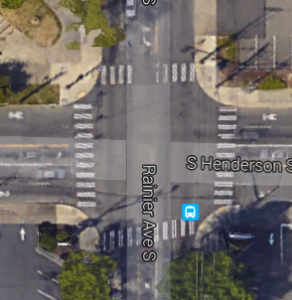
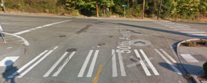
Rainier Ave S & S Henderson St “…was called out recently on Twitter as one of the most dangerous in the city. It’s a pretty straightforward design, but I guess that much fast traffic right by a couple schools is a bad combination.”
Rainier Ave S & S Henderson St
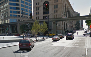
5th & Stewart – Hayden B nominates this one, “The buses cut across all four lanes of Stewart from 7th to turn left on 5th. It’s awful.”
5th & Stewart
Montlake Blvd & 520 – Lisa nominates this top vote-getter from last year, saying, “Angry drivers, all on their phones waiting to get on 520, buses, lots of pedestrians, very long lights, pedestrians darting across to catch their bus, bikes routed to sidewalks and crosswalks because of construction. It is a disastrous spot.”
This has got to be the worst pedestrian intersection in Seattle @ Montlake & 520 pic.twitter.com/7R6Yve8cA3
Montlake Blvd & NE Pacific St – Jim S says, “Beg button takes forever. lots of light rail passengers trying to cross.”
Montlake Blvd & NE Pacific St
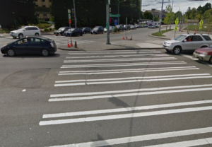
Sand Point Way & 50th Ave NE – Another one nominated by Jim S, “Really bad visibility crossing sand point from east to west, cars going way too fast in both directions.”
Sand Point Way & 50th Ave NE
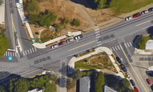
Ravenna Ave NE & NE 54th St – Yasmeen says, “I nominate Ravenna & 54th, ‘The Ravenna Park Triangle’ for being utterly unpredictable. Cars can go both ways on all three of those intersections, and during rush hour traffic backs up and people get impatient. Walking through, especially during that time, is a disaster.”
Ravenna Ave NE & NE 54th St (Ravenna Park Triangle)
N 50th St / Stone Way N / Green Lake Way N – Another nominated by Yasmeen, “My least favorite for walk wait times. There are so many intersections at that point that it can be several minutes before you get a walk light.”